Skedaddle
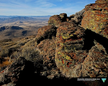
The Skedaddle Wilderness Study Area (WSA) is located in Lassen County, California (99.5%) and in Washoe County, Nevada (0.5%). The WSA contains 62,010 acres of BLM-administered land and 1,179 acres of private land that is located in seven parcels, varying in size from 40 to 640 acres. The WSA is located on the northwestern edge of the arid Great Basin, characterized by eroded volcanic mountains and expansive desert valleys (the remains of ancient lake beds). The WSA comprises an area approximately 10 by 12 miles. The Skedaddle and Amedee Mountains located in the central and southern parts of the WSA are its dominant physical features. These peaks rise from adjacent seasonally dry lake beds and low, sloping hills from elevations of 4,200 feet to the 7,680-foot summit of Skedaddle Mountain, called Hot Springs Peak. The core area of the WSA, an eroded volcanic caldera, is dominated by rugged vertical cliffs, canyons, peaks and upland basins of the Skedaddle Mountains and Amedee Mountains. The higher Skedaddle elevations support scattered small aspen groves and patches of large berry shrubs, primarily on the northern slopes. The deep canyons support riparian vegetation (willows, wild rose, and berry shrubs) and the upland basins, small grass meadows. Sagebrush and bunch grass vegetation dominate the majority of the WSA. The northern and eastern edges of the WSA are open, sagebrush-covered flats that develop into long toe slopes, leading into Skedaddle Mountain. The southern and western toe slopes are shrub- and grass covered alluvial slopes and gravel benches, the remnants of pliestocene Lake Lahontan shorelines. These toe slopes rise into the steep, rocky slopes of the Amedee Mountains-dissected by numerous canyons and ridges on the south and very steep, nearly vertical, cliffs of crumbly volcanic rock on the west (called Wendell Cliffs).
