Wichita Mountains Byway
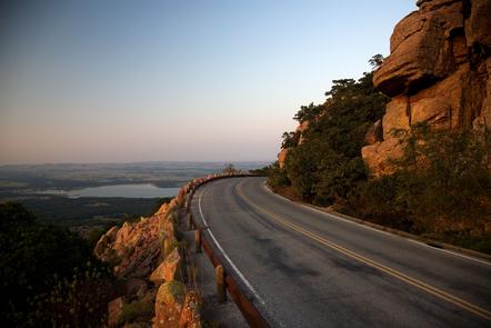
A natural beauty capable of astonishing even well-traveled visitors, the Wichita Mountains Byway guides you through the protected valleys of the 550 million-year-old Wichita Mountains, which shelter the largest remnant block of southern mixed grassland and ancient cross-timbers in North America. Experience the Wichita Mountains Wildlife Refuge, one of the oldest managed nature preserves in the Nation and the site that President Theodore Roosevelt chose for the first effort to save American bison from extinction. In 1901, this area was proclaimed a “Forest Preserve,” and then in 1905 President Theodore Roosevelt created the first “Game Preserve” at the Wichita Mountains for the nearly-extinct bison. Today, the Wichita Mountains National Wildlife Refuge maintains a herd of 600 bison, descendants of the original 15 transported from the Bronx Zoo in 1907. In addition to the bison the refuge also manages a herd of 800 elk and about 400 wild turkeys. The Black-Capped Vireo, a small species of bird historically indigenous to the area from Kansas to central Texas, now resides primarily within the refuge. With about 3,000 breeding pairs, the refuge houses one of the two remaining large populations of Black-Capped Vireo in the world. The 35-square-mile Wichita Mountains Wildlife Refuge is considered to be the largest remnant block of Central and Southern Mixed Grassland in North America and has attracted more than one million annual visitors every year since 1962.
Getting to the Byway: Dallas/Fort Worth Airport, TX Head southwest on Terminal D Access. Turn right (east) onto the ramp to TX-97 N. Keep left (north) at the fork to continue toward TX-97 N and merge onto TX-97 N. Take the TX-121 S/TX-144 W exit toward Grapevine/Ft. Worth. Merge onto TX-114 W. Take the ramp onto TX-114/US-287/US-81 continue to follow US-81. Continue on US-287 N Continue on I-44 E. Take exit 45 for OK-49 toward Carnegie/Medicine Park. Turn left (west) at OK-49 (signs for Medicine Park). Lawton- Ft. Sill Regional Airport, OK Head west on SW Coombs Road toward SW Sheridan Road. Turn right (north) on SW 23rd St/SW Sheridan Road and continue to follow Sheridan Road. Turn right (east) at NW Cache Road/NW Cache Road Square. Merge onto I-44 E/US-277 N/US-281 via the ramp to Oklahoma City. Take exit 45 for OK-49 toward Carnegie/Medicine Park. Turn left (west) at OK-49 (signs for Medicine Park). Turn left (west) onto the ramp to enter the byway. Will Rogers World Airport, OK Head southwest on Terminal Dr. toward Air Cargo Rd. Slight right (north) at Air Cargo Rd. Turn right (east) at SW 54th St. Turn right (south) onto the I-44 S. ramp. Merge onto I-44 W. Take exit 45 for OK-49 toward Carnegie/Medicine Park continue on the ramp. Wichita Falls, TX Head north on Brook Ave toward 10th St. Turn right at 10th St. Turn left at Broad St./Central Fwy/US-277. Take the ramp on the left onto I-44 E. Take exit 45 for OK-49 toward Carnegie/Medicine Park. Turn left at OK-49 (signs for Medicine Park). Navigating the Byway: ###Carnegie to Meers * Carnegie is the byway's northeastern corner. Drive west on State Highway 9 from the intersection with State Highway 58. * Turn south on State Highway 115. * Stay on State Highway 115 to Meers. ###Meers to inside the Wichita Mountains National Wildlife Refuge * Drive south on State Highway 115. * Turn west on State Highway 115/State Highway 49/Cache Meers Rd. * Turn north on State Highway 49/Scenic Highway to the end of the refuge. ###Meers to Medicine Park * Drive south on State Highway 115. * Turn east on State Highway 49 to Medicine Park. ###Medicine Park to Interstate 44 -Stay on State Highway 49 to Interstate 44 on ramp, where the byway ends. ###Medicine Park to Apache -Drive on State Highway 49 going east. -Turn north on State Highway 58. -Turn east on State Highway 19 to Boone and Apache. The byway ends at the intersection of State Highway 19 and US-281. ###Apache to Carnegie -Drive west on State Highway 19. -Turn north on State Highway 58 to Carnegie.