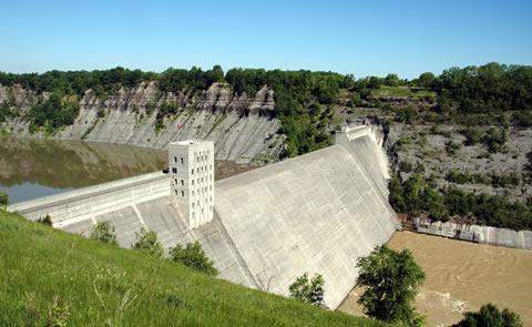
Mount Morris Dam and Recreation Area
The US Army Corps of Engineers built the Mount Morris Dam in the late 1940s to reduce flooding on the lower Genesee River. Today, the dam continues to provide flood protection along 67 miles of the Genesee River Valley from the village of Mount Morris to downtown Rochester where the river enters Lake Ontario. The US Army Corps of Engineers proudly promotes stewardship of public lands and waters. In fact, the 20 mile upstream section of the Genesee River is safe guarded by the Genesee River Protection Act of 1989, which allows the dam to hold back water only to prevent flooding. Typically, the Genesee flows freely through the dam without interference. However, when the dam is preventing flooding, the water backs up to fill Letchworth Canyon until it can be released at a rate that will not cause flooding downstream. Mount Morris Dam and Recreation Area is a day use park that offers a beautiful setting overlooking Letchworth Canyon, known as the "Grand Canyon of the East". Explore the Visitor Center to learn more about the dam or join us for a free ranger guided walking tour of the Mount Morris Dam. Spend time outside on the park grounds to enjoy captivating overlooks, picnic shelters, and a playground. This is a great place to hike, bike, or view wildlife. During the winter, explore the trails on snowshoes or cross country skis.
Mount Morris Dam and Recreation Area is located approx. 1.7 miles south of Mount Morris and 11 miles north of Nunda on SR 408. From the North: (Interstate 90) take 390S to exit 7 - Mount Morris/Letchworth, 5 miles south on Route 408. Turn onto Visitor Center Rd; continue for about 2 miles. From the South: (Route 17, I-86) take 390N to exit 6 - Sonyea, 7 miles north on Route 36, then two miles south on Route 408. Turn onto Visitor Center Rd; continue for about 2 miles.
