Gunflint Trail Scenic Byway
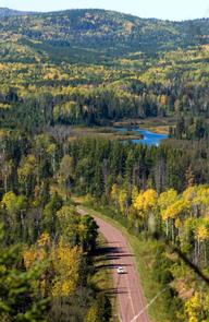
####Outdoor Excitement in a Relaxing Setting#### The Gunflint Trail passes through the northeastern corner of Minnesota near the Canadian border. The pastoral landscape of the Superior National Forest is a quiet nature destination where animals outnumber people. Travel the Gunflint Trail and experience views of beautiful Lake Superior in the byway's starting point, Grand Marais, and from the 1,000-foot elevation of the Sawtooth Mountain ridgeline. The forest changes from mixed deciduous to maple, to mixed conifer, to conifer, and to boreal forest--all home to a fascinating variety of birds and mammals. ####Fun in Any Season#### Summer and winter visits offer very different attractions. Many adventurous outdoor opportunities are available to visitors in the summer, including hiking Eagle Mountain or some of the designated trails along the byway, biking the trails, canoeing down the border lakes, or horseback riding through the woods. Or, if relaxation is what you are looking for, visitors can look for birds and other wildlife, fish the many surrounding lakes, enjoy a night camping in the Pat Bayle State Forest or just appreciate nature by driving along the byway. Winter provides chances to see more wildlife, such as deer and moose that frequent the byway and several different species of birds. The Gunflint Trail area gets a great deal of snow, making cross-country and downhill skiing favorite activities of winter visitors. Other winter activities in the area include snowmobiling, snowshoeing, dog-sledding, and ice-fishing.
Getting to the Byway: Duluth, MN * From Duluth, Minnesota, travel on Minnesota Highway 61 for 100 miles to the town of Grand Marais, Minnesota. * The Gunflint Trail begins in Grand Marais, Minnesota. Minneapolis, MN * From Minneapolis/St. Paul, Minnesota, follow Interstate 35 north to Duluth, Minnesota. * From Duluth, follow Minnesota Highway 61 to Grand Marais, Minnesota. Navigating the Byway: The Gunflint Trail starts at State Highway 61 in Grand Marais, MN. It follows Cook County Highway 12 for 57 miles northwest through the Superior National Forest to Saganaga Lake and Sea Gull Lake, where it terminates at Trail's End Campground.
