Big Lake Wilderness
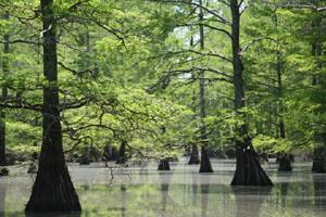
Twenty miles west of the Mississippi River, the 11,038-acre Big Lake National Wildlife Refuge was established in 1915 primarily as a migration habitat for ducks and geese using the Mississippi Flyway. The refuge lies flat, approximately 240 feet above sea level, and consists of 8,138 acres of permanent water interspersed with wooded swampland. During flood periods, 99 percent of the refuge may be submerged in water. The Little River drainage and shallow Big Lake itself (with an average depth of three feet) make up most of the open water, and the lake contains many islands standing barely above water level. Pondweed grows on the water's surface, supplying food for waterfowl. Giant bald cypress, black willow, and buttonbush thrive in swampy areas, while drier ground supports species such as cottonwood, oak, river birch, green ash, and red maple. White-tailed deer and many smaller mammals inhabit the area, and in 1993 the first bald eagle eggs hatched in nests just south of the Wilderness. No trails exist. Regulated hunting and fishing are permitted. Big Lake is the state's smallest Wilderness and the only one in eastern Arkansas.
Big Lake NWR and the Big Lake Wilderness are located in northeast Arkansas adjacent to the bootheel of Missouri. From Blytheville, travel west on State Highway 18 approximately 15 miles. From Jonesboro, travel east on State Highway 18 approximately 35 miles. Headquarters is located on the north side of the highway. Various directional signs are located along the route. Contact Refuge Office for information and maps of the area. Boat, canoe, or kayak is required to enter the wilderness area. Subject to flooding during any part of year. Water levels are highly variable.
